.png)
Supporting Ghana Water with Esri applications

Jelmer Akkerman
Business Line DirectorAs you can read in our article 'The Sustainable Development Goals of Tensing', at Tensing we think it's important to support initiatives that help make the world a better place. We do this by starting and supporting projects that contribute to the United Nations' Sustainable Development Goals. One of those goals is: 6. Clean drinking water and sanitation. In this article, we would like to explain to you how our project with Ghana Water contributes to this development goal.
As part of our corporate social responsibility programme, Tensing launched a project in partnership with VEI in autumn 2021, under the umbrella of the WaterWorX programme. The aim of the project is to support the Technology & Innovation department within Ghana Water in the adoption and use of their newly acquired ArcGIS Enterprise environment.
VEI and WaterWorx
Vei was founded in 2005 by two Dutch water utilities (Vitens and Evides) to provide peer-to-peer support to partner utilities abroad to improve their operations and increase access to potable water. Now five more Dutch utilities have joined VEI: WML, Waterbedrijf Groningen, Brabant Water, WLN and PWN.
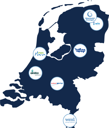
Together with the remaining three Dutch water utilities, VEI is implementing the WaterworX (WWX) which is a Water Operator Partnership program among 40 utilities in mainly Africa and Asia. The WWX partnership program aims to increase access to sustainable water services for 10 million people between 2017 en 2030.
GWCL: The national drinking water company of Ghana
Ghana Water Company Limited (GWCL) is the national water utility in Ghana and is responsible for supplying drinking water to all urban communities in the country. They currently operate 90 water supply systems spread across the country which covers about 77% of the urban areas.
The strong annual urban growth in Ghana translates into a large number of new service connections required to connect customers to GWCL's water supply systems. Each year Ghana Water adds around 30-40,000 connections to their distribution network. To enable the realization of the connections, effective information collection techniques and recording in the company's GIS are required.
This is where Tensing's support comes in. Tensing worked with the GIS team at GWCL's headquarters and that of the Accra East Region to design and test a GIS-based workflow for the registration of new service connections by implementing a series of apps using Esri technology.
The project approach
The aim of the project was to provide a solution that Ghana Water could immediately deploy in day-to-day operational work by leveraging the available technology and knowledge of the Ghana Water's GIS team. Together, we developed the solution using an iterative project approach.
Over several months, a prototype was developed based on the information gathered during online workshops with Ghana Water staff. After travel restrictions due to the COVID pandemic were lifted, a GIS consultant from Tensing planned the first visit to Ghana. This visit served several purposes:
- Capacity building through training in Esri Enterprise technology.
- Refinement of the prototype solution.
- Gathering feedback for the completion of the solution.
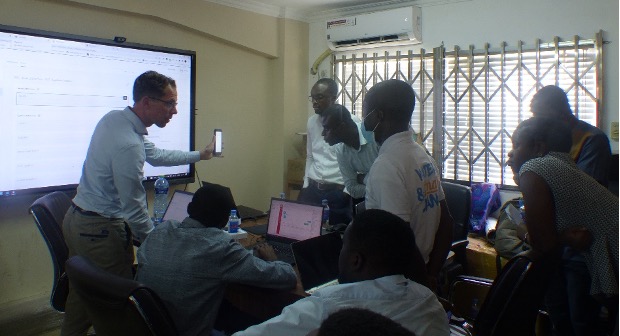
GIS-consultant Jelmer during his visit in Ghana.
With the feedback gathered from this field visit, the team made improvements to the solution before a second field visit to complete the project was scheduled in summer 2022. This second visit focused on:
- Testing of the solution in the selected pilot area in the Accra East region.
- Knowledge transfer and additional training.
- Transfer of the developed solution to the GIS team and formal closure of the project.
The solution
The developed solution supports the business process for registering new service connections to Ghana Water's drinking water network. All components of the solution were delivered using configuration of off-the-shelf technology available in or on top of Ghana Water's existing Esri ArcGIS Enterprise platform.
As a first step, a methodology was established that describes the stakeholders, tasks and applications in each step of the process and connects office staff with their colleagues conducting surveys in the field.
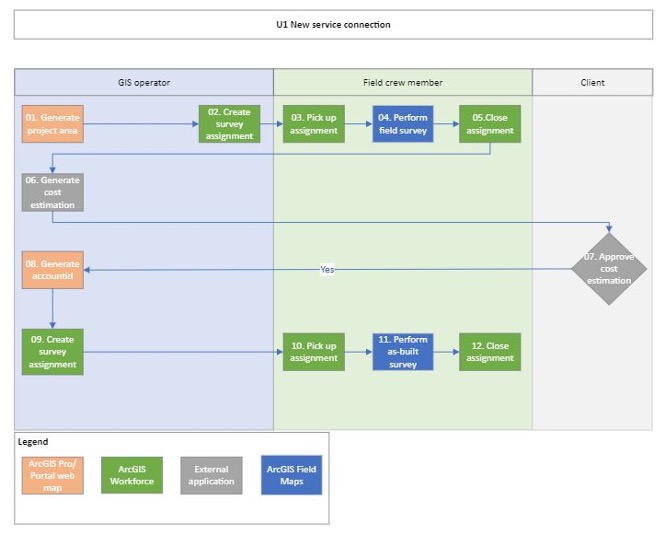
The established methodology.
As the second step, the proposed methodology was established by configuring the individual Esri components, apps and extensions:
- ArcGIS Pro
- ArcGIS Portal
- ArcGIS Workflow
- ArcGIS Field Maps
- ArcGIS Operations Dashboard
- VertiGIS Studio Workflow
The above components were brought together in a process using the right component using app linking.
The prototype testing and feedback additionally these steps were taken.
- Patches and minor updates to the Enterprise environment were applied to add essential functionality.
- Automation via Arcade scripting was implemented wherever possible to reduce user input.
- A Proof-of-Concept was developed to integrate address information from the national Ghana Post organization into the solution, using VertiGIS Studio Workflow to use the Ghana Post API for geocoding. The developed workflow was incorporated into the web viewer in ArcGIS Enterprise that is part of the solution, allowing a new service connection to be accurately assigned to the correct location based on a postal address; something that was time-consuming and difficult to derive the correct location with other methods.
- A summary of the collected data and status information for each new service connection request was made available in ArcGIS Operations Dashboard for authorized users within the organization.
The next steps
Ghana Water will use the solution in the Accra East region; collecting suggestions for further improvements to optimize the solution along the way in combination with these additional improvements already identified during the project itself:
- Data model optimization.
- Maximizing the use of Portal applications in GIS operations.
- Comprehensive integration of the solution with other business applications.
After successful adaptation in Accra East region, Ghana Water is keen to roll out the solution nation wide so that in the future all new service connections are digitally recorded to ensure the GIS data is kept up-to-date and changes due to administrational inaccuracies are minimized in support of amongst other the fight against commercial losses.
Would you like to know more about our Ghana Water project or how you can join us in helping with development goals? Get in touch with us!