Labs
Career
Support
Blog
Consultancy
Software
Training
References
Industries
About us
Tensing
Career
Support
Blog
Blog
Tensing Blog
FME
ESRI
GIS
ArcGIS
Tensing
news
Safe Software
ETL
blog
Innovation
Spatial Data Science
insights
Blog
Three more reasons why to use Tensing’s 3D GeoViewer
Innovation,GIS,blog,BIM,3d geoviewer
Search
Blog
Successful launch of 3D GeoViewer
Innovation,GIS,Tensing,blog,BIM
Blog
Faster permits for architects thanks to geogr...
Innovation,GIS,Geo-ICT,blog,BIM,3D,insights
Give context to your design by providing it w...
Innovation,GIS,Geo-ICT,BIM
Blog
Three more reasons why to use Tensing’s 3D Ge...
Innovation,GIS,blog,BIM,3d geoviewer
Blog
Successful launch of 3D GeoViewer
Innovation,GIS,Tensing,blog,BIM
Blog
Faster permits for architects thanks to geogr...
Innovation,GIS,Geo-ICT,blog,BIM,3D,insights
Give context to your design by providing it w...
Innovation,GIS,Geo-ICT,BIM
What attributes must files have to use the 3D...
Innovation,GIS,Geo-ICT,BIM
Analysis at the heart of the technological re...
Innovation,ESRI,FME,Spatial Data Science,Tensing,Vision
How do you start with real-time GIS and IoT?
Innovation,Best practices,GIS,Vision
Recognition of criminal activities
Innovation,ArcGIS,ESRI,Business Consultancy,GIS,Spatial Data Science,Case Study,insights,Safety & Security,Vision
Undermining crime in vulnerable real estate
Innovation,ArcGIS
Blog
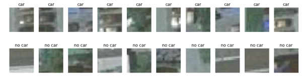
Object recognition with Deep Learning for mor...
Innovation,blog
A look back at the FME World Tour 2018
Innovation,ETL,FME
Wizards and Point Clouds
Innovation,ESRI,Cloud,Point Cloud,Best practices,Vision,Centralized data
All blogs