


.png)
Proof of Concept Esri Utility Network at Pidpa

Jelmer Akkerman
Business Line DirectorPidpa is one of the largest water companies in Belgium and has been an active user of the Esri ArcGIS platform since 2003. They follow new developments closely. Together we are convinced that a further deepening in the use of GIS will further optimize the business processes. Pidpa tries to continuously generate added value through the use of GIS in a wide spectrum of work processes, Tensing helps them in this process.
In a previous article I described how a Geographic Information System helps streamline Pidpa's management process. By using geographical information, a drinking water company such as Pidpa can perform its asset management tasks more efficiently, especially if this is effectively combined with information from other business applications (such as SAP).
In 2019 I looked into the future together with Bart Reynaert, Geo-ICT architect at Pidpa. How would the development of the GIS landscape at Pidpa proceed and what role would Esri's Utility Network Management (UN) play in this. Now, more than half a year later, I want to look back on the steps taken and the progress we have made. The Proof of Concept (POC) has now been completed. How did that go and what are the next steps? You read it in this article.
WHY Pidpa made THE STEP TO THE ESRI UTILITY NETWORK?
Before I go on about the why, let me give a brief explanation of the Utility Network itself. The UN enables organizations to model, edit and analyze all assets in their network. Network modeling can be done quickly and easily in great detail. In addition, the UN offers good support over multiple types of devices, so that the network can also be modeled from the field.
- Instant collection of data at the level of detail in the field: allowing data to be generated immediately at the time and place to which it applies;
- Use more extensive analysis options on (the performance of) the network;
- Replacing custom applications with standard functionality and simplifying the IT landscape. This will help the organization not only to be able to carry out upgrades more often, but also to perform each upgrade faster. This has the advantage that it becomes easier to offer new possibilities to users within the organization and stakeholders outside.
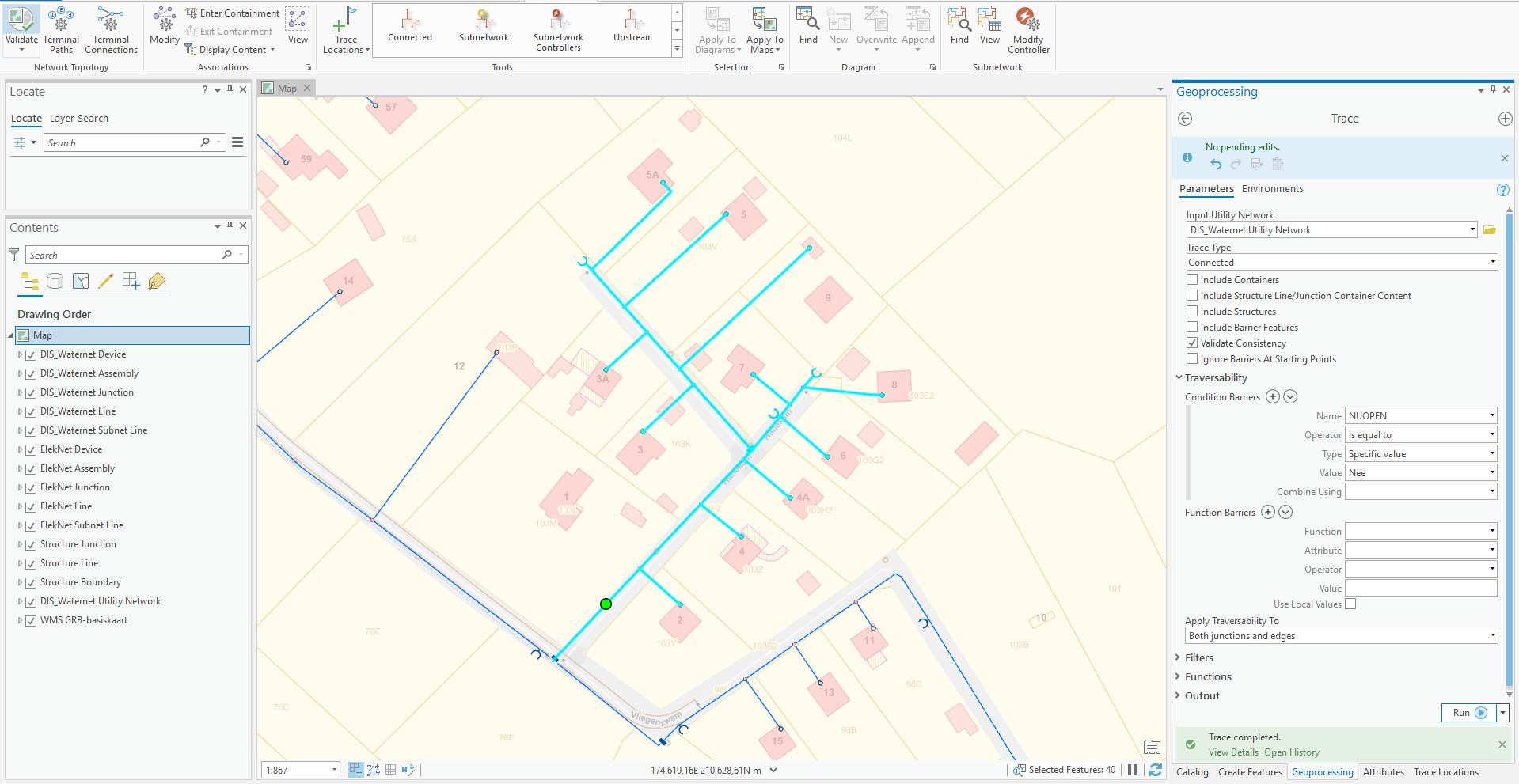
Pidpa's ArcGIS Pro interface when performing a trace
OUR JOINT APPROACH
In the period between October 2019 and March 2020, a Proof of Concept (POC) was carried out around the UN and Web GIS to test new functionalities and estimate the effort required for (data) migration. This POC was carried out with the support of specialists from Tensing and Esri Nederland. The working group was deliberately kept small in order to collaborate quickly, effectively and pragmatically. In total, about 80 'use cases' were tested, divided into three categories:-
- Database: data model and data migration;
- Desktop (edit) environment;
- Web GIS (GeoLink, Pidpa's environment based on GeoCortex from Latitude GeoGraphics).
For the POC we wanted to develop one representative municipality, out of a total of 65 municipalities in the service area of Pidpa. Pidpa's existing data model for the drinking water network in GIS was rebuilt in a number of iterations in the UN and the complete dataset from the geometric network for the municipality was migrated to the UN. The data needed surprisingly little adjustment, partly because Pidpa put focus on the quality of data in recent years. Business rules, such as diameter-material combinations and connectivity rules, from existing applications have been translated into configuration in the UN.
The Result
The extensive configuration options of the UN proved sufficient to replace almost all current custom additions in the desktop environment. This makes the IT landscape a bit simpler. The additional upgrade of ArcGIS Enterprise and the further integration with the web GIS philosophy showed that it can give users in the organization a better insight into geographical data, for example the current status of the network. In addition, the application of specific apps, such as the Operations Dashboard, makes it possible to provide this data in an insightful way to users who do not use GIS on a daily basis, which further increases the reach of GIS in the organization. A practical example of such a dashboard that we have developed provides insight into the current state of fire hydrant inspections.
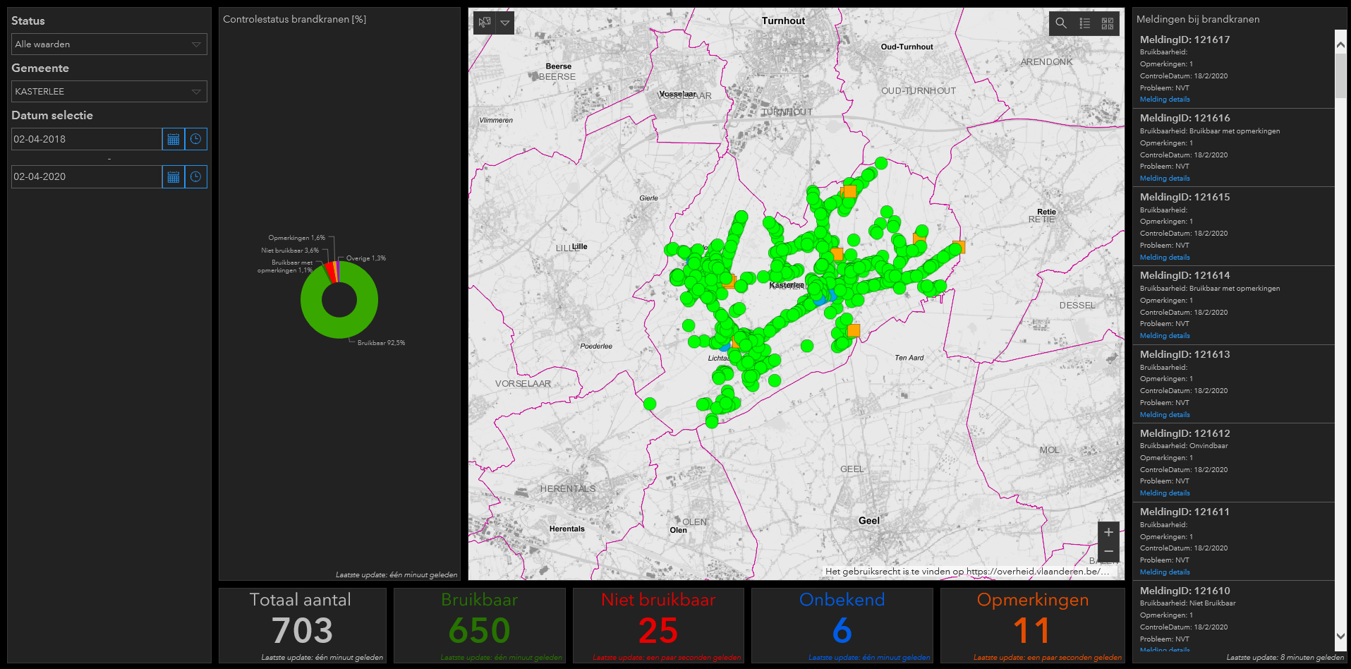
Screen capture of the dashboard for fire hydrant inspections
WHAT ARE THE POINTS OF Attention?
Full understanding of the UN, data modeling and extensive configuration options require extensive knowledge of the current GIS landscape, the implemented data model and insight into connections with other systems. It resulted in a steep learning curve that we went through together. Esri and Tensing brought their knowledge and expertise in the field of GIS and the Utility Network, which was supplemented by the extensive knowledge from Pidpa regarding their own data network. In other words, the knowledge of all parties are important ingredients for a well-organized migration process.
Changes, such as UN's branch versioning mechanism and services-based architecture, are another reason for careful consideration of any changes to existing GIS services, workflows or links with other systems.
The road to implementation
A second test phase is planned on the way to the commissioning of the production environment, which will focus on:
- Installation and configuration of required hardware, including performance;
- Data migration for the entire servicet area of Pidpa;
- Coupling with additional systems;
- Adjusting and developing required tools for optimal use of UN in the web-GIS environment;
- Optimizing work processes.
A delegation of users will gain initial experience with the new environment during this test phase. Their feedback will help to continuously improve the environment. Training users in new software plus the change of working processes is also an important part of the transition to the new environment. The ambition is to realize the step towards the production environment by the end of 2020. Then we will share the third part of this blog series with you.
CONCLUSION
UN offers the potential that will help Pidpa to take the next step in the further integration of geographical data into its business operations. There is still work to be done in the phase to the planned commissioning and a steep learning curve has been experienced during the POC, but the working group is satisfied with the result achieved: that is enough to take the next steps to the go-live moment in the production phase.
.jpg?width=744&name=LinkedIn-banner-Pidpa-EN%20(1).jpg)
Do you want to know more about the latest developments in the Utility Network and our experiences during this Proof of Concept? Please contact us and we think along with you about the potential of the Utility Network for your organization.
Leave your details and I will contact you as soon as possible.