


.png)
Geo-data for streamlining asset management process at Pidpa

Jelmer Akkerman
Business Line DirectorAbout the marriage between GIS and SAP and how this strengthens cooperation.
Pidpa provides the public water distribution network for a large part of the province of Antwerp, making it one of the largest water companies in Belgium. The organization is responsible for the drinking water supply of no less than 1.2 million people in 65 municipalities and sewer management in 34 municipalities. Pidpa logically invests a lot of time and resources in managing this network. To give a better picture of the infrastructure: Pidpa has around 13,000 kilometers of drinking water network, 3,500 kilometers of sewerage network, 1,800 kilometers of canals and thousands of valves, fire hydrants and control valves and dozens of water towers and booster stations. All these assets must be continuously maintained / renewed and malfunctions must be remedied as efficiently as possible. To streamline this management process, Pidpa makes intensive use of geo-data. Data from the field is mapped and made centrally available.
Mapping, streamlining and making that data available is based on the ArcGIS platform, a powerful Geographic Information System (GIS). As a GIS specialist with large experience in the world of utilities, Tensing is closely involved in setting up, optimizing and modernizing this Pidpa geodriven management process.
In this article I describe what the use of geo-data Pidpa has brought. Together with Bart Reynaert, Geo-IT architect at Pidpa, I also take a look at the future. What steps need to be taken and what role does, for example, the development of Esri's "Utility Network Management Extension" (UNM) play in this?
What did we achieve?
GIS has been used broadly within Pidpa for quite some time, but the initial need came from the technical people who manage the drinking water network. Pidpa has been using the ArcGIS platform since 2003, where it was used to register the assets of the water company. However, based on stricter laws and regulations, a more critical consumer and the cost aspect Pidpa had to organize its asset management processes more efficiently. Pidpa, together with Tensing and Esri, searched (for the GIS component) and Ideo (for the SAP component) the solution for improving data flows around the service and maintenance department. The reason to start here is the fact that these departments mostly determine how and to what extent assets can be managed in a cost-efficient manner.
The biggest problem was that the work assignments for assets could not be mapped precisely enough. This was partly due to the fact that not all assets had been named in SAP. Order creation was at street level or "an object somewhere in the area of..". A technician then had to search for the relevant object. Waist of time! The display of work and maintenance locations was therefore insufficiently accurate. There was also no clear maintenance history and the employees in the field made use of a paper flow. A considerable increase in efficiency could and should therefore be made.
The data flows around service and maintenance are complex due to the maze of mutual tasks. That is why Tensing has built a number of smart functionalities to optimally use the geographic data from the GIS and the maintenance data from SAP. This data is fully unlocked and is centrally available for the responsible employees via, among other things, GeoLink and SAP mobile working. That may sound a bit abstract, but in practice it means that the work planner can get started on the basis of maintenance history per asset, the planner can plan more efficiently and the technician can get to work more focused (think of location and method of implementation) . The work and the result can be fed back directly from the field to GIS and SAP via a mobile application.
To strengthen cooperation between the various departments and cooperation with organizations in the chain, the GeoLink environment set up by Tensing is used. GeoLink is a webgis environment based on ArcGIS Enterprise and GeoCortex where various information, such as assets, work locations and reports are made available to the various business departments within Pidpa. This functional viewer from Pidpa allows the user to just 'view' on the basis of tools built by Tensing, also draw new objects and modify existing objects and / or attribute information. Internally, this functional viewer is frequently used by more than 400 people.
GeoLink is also used externally and used by more than 3,000 stakeholders. The SAP data of work performed is visualized with the help of GIS and in this way stakeholders such as municipalities, local residents and fire brigade are informed in real time. Via a map you can follow the status or progress of reports and current work locations in an understandable and well-arranged manner.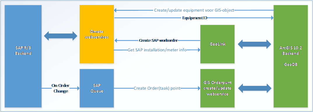
Image: the link between SAP and ArcGIS (including the process behind it) depicted
By linking geographic data from the GIS to the service and maintenance data in SAP, an enormous efficiency gain has been made in work order creation and mobile working. As a GIS partner, Tensing assisted in this project. The results at a glance:
- More efficient work processes
Many SAP work orders can now be created from GIS. This data can be managed in SAP for the efficient running of maintenance and quality processes. - Act adequately
Because the data is more accurate and centrally available, more action can be taken in the event of a failure. Where previously an asset location was described, it can now be displayed exactly on the map and can therefore be located immediately. - Better communication stakeholders
Because the data is visualized on the basis of GIS, it is accessible to stakeholders in an easy way . They can view and post messages via a map, follow service and maintenance status and view current work locations. 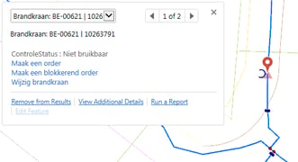 Reduced work order threshold lower and order creation more precise
The representation of work and fault locations has become more accurate (and therefore mobile working is more efficient). Because the maintenance engineer from the field can communicate with SAP applications in a user-friendly way through the GIS application, processing a work order has become easier.
The majority of work orders for drinking water and sewage are now made from GIS. In other words, the use of GIS has brought Pidpa a lot and is a leap forward in geo-communication and more efficient collaboration. It provides insight into - put flat - who does what at what time at which location with which means. Herein is the:
- Who: the deployment of people and resources;
- What: the content of the work order that becomes visible in GIS;
- Where: the location;
- When: when the order is executed. The status and date are displayed in GIS and this data is continuously updated from SAP.
A vision of the future
We speak with Bart Reynaert from Pidpa about his vision on the future of GIS within the organization: "The big wish for the future is to keep the chosen path and to gain even more value from GIS through smart links and integrations with SAP. The GeoLink environment is an important pillar in this. It ensures a better data structure, faster data availability and fewer paper flows. Moreover, Geolink is a cornerstone for the further reduction of "over-work" by increasingly registering data digitally at the place and time where it originates. This will enable a number of employees to focus more on checking, analyzing and optimally using the data in the asset management processes''.
Bart continues: ''Thanks to these advantages, there is a lot going on internally, the support for GIS and the use of geo-data have grown considerably with the successes already achieved. For example, the need for GIS expands from the technical side to the administrative side, for example the use of geo-data and a planning tool for smarter deployment of field staff to limit travel distance".
The positive changes mentioned above will have to be continued in the coming years. With the help of Tensing, the GeoLink environment must transform even more from a viewer to a functional edit tool, with which an even larger group of people in the field and other stakeholders can work.
One change that will help with this is the implementation of UNM. With UNM, an organization is able to model, edit and analyze all assets in their network. This way the UNM will be able to model the network in detail faster and easier. In addition, the UNM offers better support across multiple types of devices, so that the network can also be modeled from the field. Want to know more about the Utility network. Read our blog article: Utility Network, is it time?
A few points of the roadmap at a glance:- start using the newest functionalities of GeoCortex and ArcGIS;
- expanding the GeoLink view application to an efficiently usable application to capture and edit more data.
- strengthen the whole function with apps such as the Esri collector or Survey123 on the one hand, and improve the follow-up of "what we are doing where" on the other with the help of dashboards.
Bart: "The aim of these changes is that everyone (from field staff to the CEO) must be able to work with the applications in a user-friendly way. For this, the system must remain very intuitive and user-friendly. These are conditions for the successful implementation of the change process".
The further development of the GIS environment will start next fall with a Proof-of-Concept. Hereby new functionality is thoroughly investigated and tested. The investment of the POC-phase must be able to evolve directly into an implementable scenario. Tensing and Esri Nederland will support Pidpa in the full spectrum of advice, development, installation, configuration and design plus the rollout of various tools.
Bart is very satisfied with the pragmatic cooperation with Tensing. "Both parties learn from each other and that appeals. Thanks to Tensing consultants, who are realizing solutions on our ArcGIS platform at a rapid pace, Pidpa has a future-proof GIS solution in house. We look forward to the next steps in our collaboration to further broaden and optimize the use of GIS within Pidpa. The point of departure here is that new techniques can be used by everyone and directly add value to the organization and processes."
.jpg?width=743&name=LinkedIn-banner-Pidpa-EN%20(1).jpg)
Curious how Tensing can streamline your processes based on smart use of geo data? Or would you like to discuss how ArcGIS can support your organization? Then feel free to schedule an appointment.